Sharpening the View from Orbit: AERU-NET’s Adaptive Edge Recovery Approach to Satellite Image Super-Resolution
Research from the CUEE MDAP Lab, published in IEEE Access in March 2025, introduces AERU-Net — a lightweight deep learning model that delivers state-of-the-art super-resolution for satellite and aerial imagery with a fraction of the computational cost of leading alternatives.
Satellite and aerial images are essential tools for understanding our planet, but they come with an inherent limitation: resolution. atmospheric conditions, sensor physics, and orbital distance all reduce the level of detail available in raw satellite imagery. When a decision depends on identifying a collapsed building, a shifting coastline, or a vehicle on a runway, that missing detail matters.
Remote Sensing Image Super-Resolution (RSISR) is the AI-driven process of recovering that lost detail — reconstructing sharp, high-resolution images from low-resolution inputs using deep learning. Researchers at Chulalongkorn University’s CUEE MDAP Lab have developed a new model that pushes this capability significantly further.
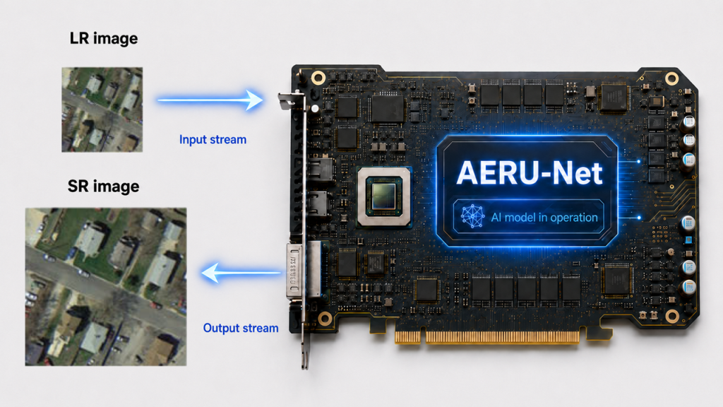
Published in IEEE Access in (March 2025), AERU-Net — the Adaptive Edge Recovery and Attention U-Shaped Network — is built by Amir Hajian and Supavadee Aramvith to solve a specific problem that existing models consistently fail at: recovering sharp edges and fine structural boundaries in complex satellite scenes. It does this at just 706,000 parameters, while outperforming models with over 37 million.
⚙️ The Challenge — and How AERU-Net Resolves It
Existing AI super-resolution models work well on natural photos but fall short on satellite imagery, where scene diversity, structural complexity, and edge fidelity demand something more targeted. AERU-Net addresses each limitation with a dedicated architectural component.
| ⚠ Challenge | ✓ AERU-Net’s Response |
|---|---|
01 Blurred edge patternsBoundaries between buildings, roads, and terrain are structurally critical but difficult to reconstruct — especially where multiple land types converge. | ERB Edge Recovery Block Applies Sobel and Laplacian filters at every encoder and decoder stage to actively detect and preserve edges throughout the entire reconstruction process. |
02 One-size-fits-all processing A forest, a city grid, and a coastline each require different levels of detail. Most models apply uniform processing and underperform across varied scene types. | CAM-SAM Dual Attention ModulesChannel Attention (CAM) selects the most relevant data channels per scene; Spatial Attention (SAM) focuses processing on complex regions and suppresses uniform areas. |
03 Edge detail lost between network levels In deep networks, fine structural information degrades as it passes through multiple processing stages — existing skip connections don’t prevent this systematically. | CSI-LEP Cross-Scale Interaction + Edge PreserverAdaptive CSI shares features bidirectionally across all three network levels; the Laplacian Edge Preserver explicitly reinforces structural edges at each scale transition. |
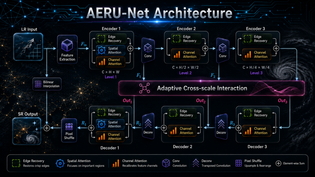
Figure 2 — AERU-Net data flow: from low-resolution input through encoder–decoder stages to super-resolved output
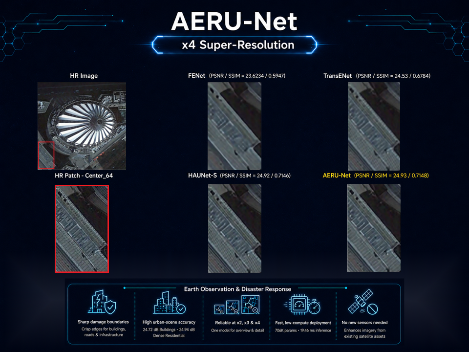
| 34.64 dB PSNR on UCMerced ×2 — best among 12 models | 706 K Parameters vs. 37M for TransENet | 19.46 ms Inference time — lightweight & deployable |
🌍 Why It Matters: Real-World Applications
Sharper satellite images are not just a technical achievement. — They have direct practical value across market sectors where what you can see from space determines what happens on the ground.
Earth Observation & Disaster Response Sector
In the public safety and emergency management market, response time and situational accuracy are everything. AERU-Net enhances satellite imagery resolution for rapid damage assessment following earthquakes, volcanic eruptions, and typhoons —enabling operators to identify collapsed structures, inundated road networks, and blocked evacuation corridors with pixel-level precision. The model’s strong performance on dense urban scene classes (Building 24.72 dB , Dense Resident : 24.94 dB on UCMerced at ×4 scale) makes it directly applicable to the high-stakes imagery analysis workflows that this sector depends on.

Environmental Monitoring & Land Management Sector
The geospatial intelligence and environmental compliance market demands precise, repeatable classification of land cover from satellite data. Vegetation mapping, coastal change detection, and urban expansion monitoring all require the ability to distinguish fine boundaries between adjacent terrain types. AERU-Net’s LEP-enhanced edge preservation delivers higher-confidence land-use classification from existing satellite assets, reducing the need for supplementary aerial surveys and enabling more accurate long-term environmental impact assessments without additional sensor infrastructure investment.
📚In summary
AERU-Net shows that the right architectural choices — targeted edge recovery, adaptive attention, and cross-scale feature sharing — can produce top-tier satellite image super-resolution in a model small enough to deploy practically. It’s a meaningful step forward for anyone who needs to see the world more clearly from above.
🔗Learn More & Official Links
Explore official resources and related Design Gateway content for more information about CUEE MDAP Lab research and FPGA & AI collaboration.
- CUEE MDAP Official Website
- Collaboration Announcement: MDAP × Design Gateway
- Browse FPGA & AI articles on Design Gateway’s Blog
📩 Contact Us
Interested in collaborating with or learning more about research from the CUEE MDAP Lab — including AERU-Net and related work in areas such as:
- Anomaly Detection
- Digital Image and Video Super-Resolution Techniques
- Digital Video Coding
- Face Recognition and Emotional Expression
- Remote Sensing Image Enhancement
Please reach out via Design Gateway to connect with the research team. 🚀