Remote Sensing Image Enhancement for Next-Generation Satellite Services

Improving satellite image quality can follow two paths. The conventional path depends on new hardware investment, while the HybridATNet path enhances the value of images already captured by existing sensors. Developed from research at Chulalongkorn University, HybridATNet applies AI-based super-resolution to improve the clarity and usefulness of remote sensing imagery.
🔍 Overview
For satellite service providers and remote sensing users, improving spatial image quality does not always require replacing the payload or sensor system. AI-based super-resolution can enhance existing image archives and incoming imagery within the current image-processing workflow.
Conventional Path: New Hardware
- Upgrade sensors to improve spatial resolution.
- Requires a long development and deployment timeline.
- Requires significant investment before the service upgrade.
- Existing image archives remain unchanged.
HybridATNet Path: AI Enhancement
- Enhance images from existing sensors.
- Integrate into the current image-processing flow.
- Increase the value of both archived and live images.
- Improve service quality without requiring a new payload.
⚙️ What Makes HybridATNet Different?
HybridATNet combines multiple image-understanding techniques into a single processing pipeline, helping preserve both fine details and large-scale structures commonly found in satellite and aerial imagery.
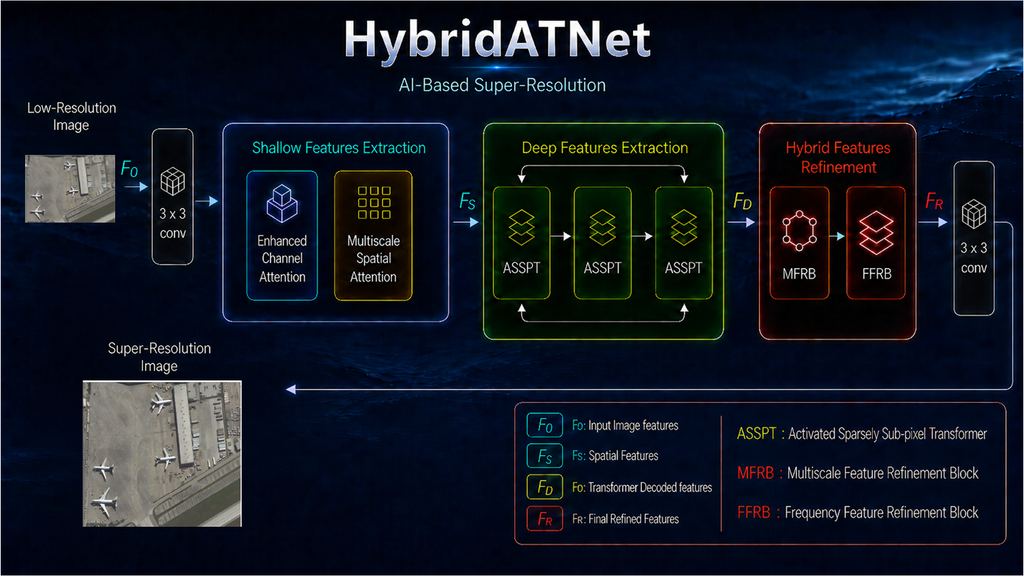
Enhanced Channel Attention
Identifies important image features and helps the model focus on meaningful information instead of treating all feature channels equally.
Multi-Scale Spatial Attention
Analyzes image structures at multiple scales, helping the model recognize both small objects and larger geographical patterns.
Residual Atrous Spatial Pyramid Pooling
Expands the effective field of view without excessive computational cost, enabling broader contextual understanding.
Hybrid CNN-Transformer Architecture
Combines local-detail extraction from CNNs with global scene understanding from Transformer networks.
Sparse Transformer Processing
Captures long-range relationships across the image while reducing computational complexity compared with conventional Transformer approaches.
Hybrid Feature Refinement
Processes image information in both spatial and frequency domains to sharpen structures, preserve edges, and suppress unwanted noise.
🚀 Performance Validation
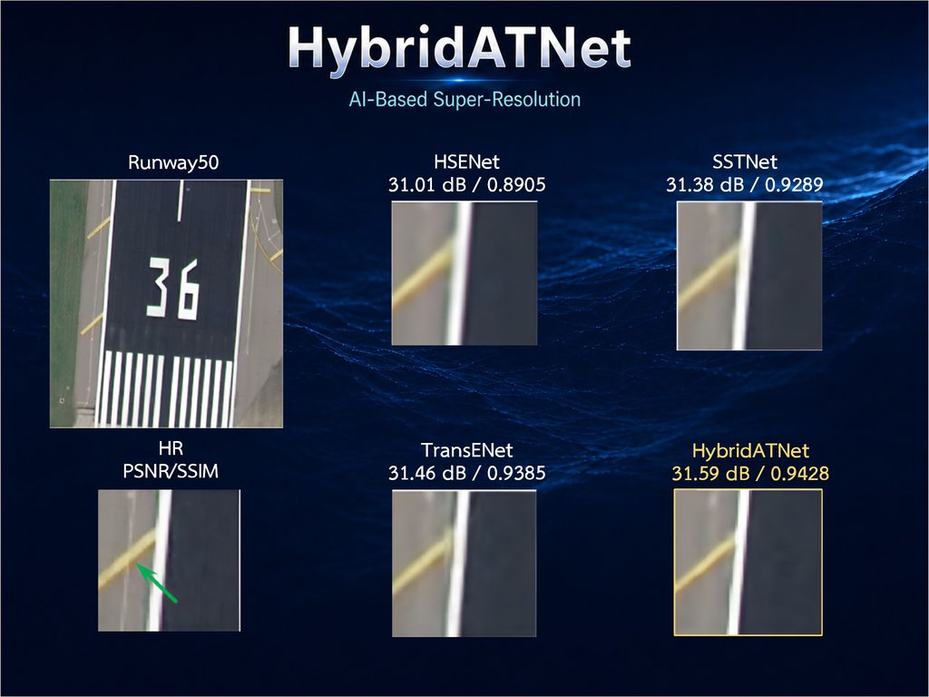
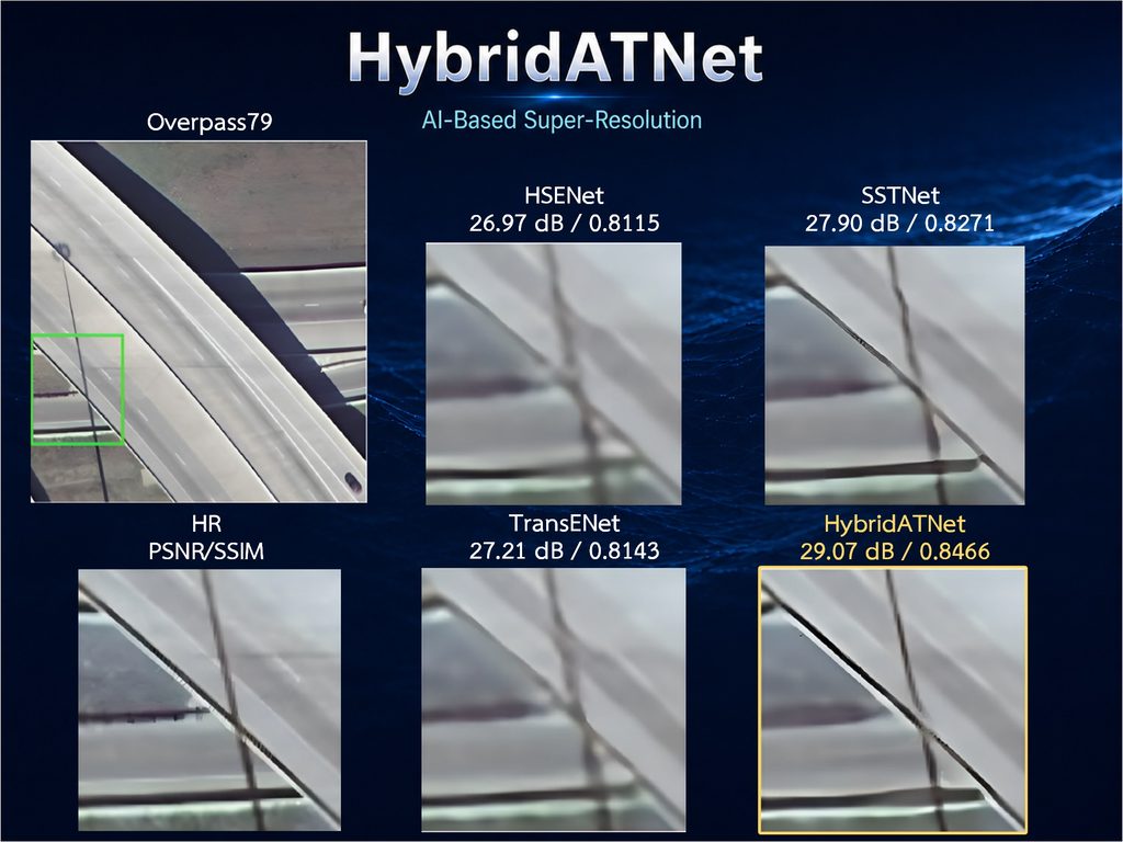
HybridATNet was validated using the AID remote sensing benchmark dataset at the challenging ×4 enhancement scale. In the source material, it outperformed traditional interpolation and several well-known super-resolution models in both PSNR and SSIM.
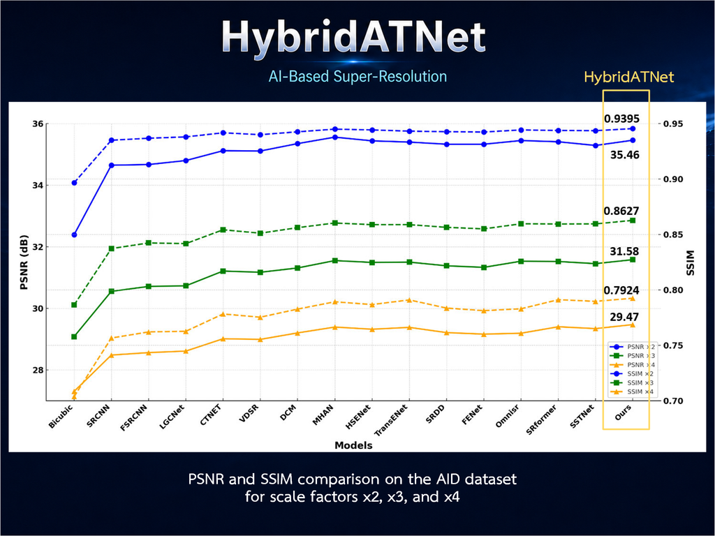
| Method | Approach | PSNR (dB) | SSIM |
|---|---|---|---|
| Bicubic | Traditional interpolation | 27.30 | 0.7036 |
| SRCNN | Early CNN-based SR | 28.48 | 0.7565 |
| VDSR | Deep CNN-based SR | 28.99 | 0.7753 |
| SRFormer | Transformer-based SR | 29.40 | 0.7911 |
| HybridATNet | Hybrid CNN-Transformer SR | 29.47 | 0.7924 |
* Higher PSNR and SSIM indicate better reconstruction quality. HybridATNet achieved the highest score among the selected comparison methods while maintaining an efficient architecture.
15%
fewer parameters than comparable Transformer models.
18%
fewer floating-point operations (FLOPs) per image.
×4
Validated at ×4 enhancement scale, alongside ×2 and ×3.
📌 Applications
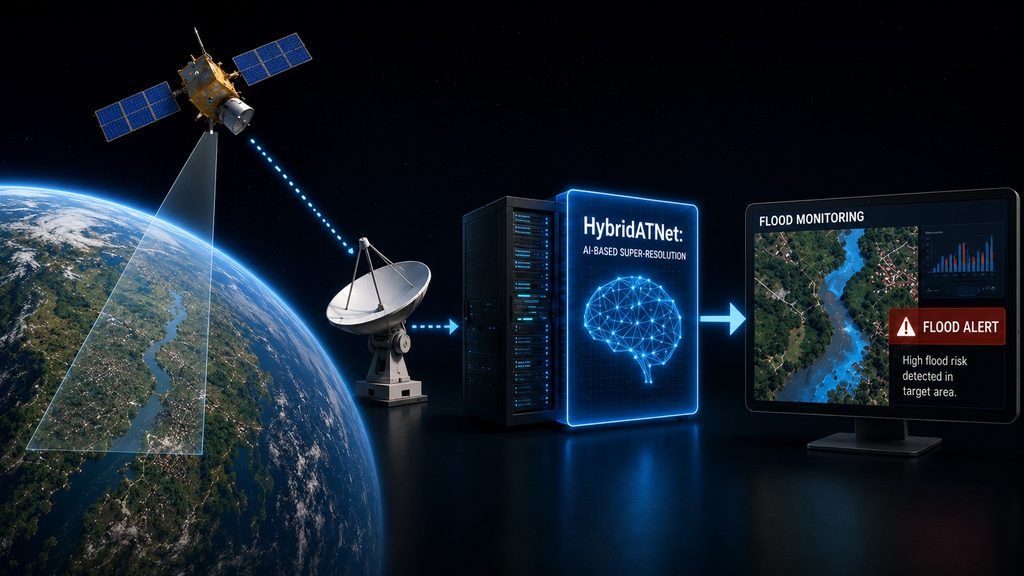
Remote sensing image enhancement can support multiple satellite-service markets where clearer structures improve downstream visual interpretation and analysis.
Disaster Response
Support faster visual assessment of flood zones, damaged infrastructure, blocked roads, and affected residential areas after major events.
Infrastructure Monitoring
Improve visibility of roads, bridges, ports, airports, runways, and industrial facilities for inspection, planning, and change detection workflows.
Agriculture & Land Management
Reveal clearer field boundaries, land-use transitions, irrigation layouts, and crop-region structures for agricultural intelligence services.
Environmental Monitoring
Assist analysis of forests, coastlines, wetlands, rivers, and natural boundary changes where image clarity improves long-term monitoring value.
✅ Final Takeaway
HybridATNet provides an AI-based path to improve the visual quality of remote sensing imagery without requiring immediate sensor replacement. By combining CNN-based local feature extraction, Transformer-based global understanding, and hybrid feature refinement, the approach is designed to improve image detail while maintaining computational efficiency.
📚 Research Background
HybridATNet is based on peer-reviewed research developed at the Multimedia Data Analytics and Processing Research Unit, Chulalongkorn University, Thailand.
N. Sultan, W. Ruangsang, and S. Aramvith, “HybridATNet: Multi-Scale Attention and Hybrid Feature Refinement Network for Remote Sensing Image Super-Resolution,” IEEE Access, vol. 13, pp. 159979–159997, 2025.Published 9 September 2025 · DOI: 10.1109/ACCESS.2025.3608009 · Open access (CC BY 4.0)
🔗Learn More & Official Links
Explore official resources and related Design Gateway content for more information about CUEE MDAP Lab research and FPGA & AI collaboration.
📩 Contact Us
Interested in collaborating with or learning more about research from the CUEE MDAP Lab — including HybridATNet and related work in areas such as:
- Anomaly Detection
- Digital Image and Video Super-Resolution Techniques
- Digital Video Coding
- Face Recognition and Emotional Expression
- Remote Sensing Image Enhancement
- Medical – stereo endoscopic SR, Brain MRI reviews
Please reach out via Design Gateway to connect with the research team. 🚀